


Informatics Educational Institutions & Programs
Size of this preview: 800 × 370 pixels. Other resolutions: 320 × 148 pixels | 640 × 296 pixels | 1,357 × 628 pixels.
Original file (1,357 × 628 pixels, file size: 43 KB, MIME type: image/png)
Summary
From en:Image:France colonial Empire10.png List of internet sources (to complete) :
- http://www.tu-dresden.de/sulcifra/quebec/geschqu/paris.htm
- http://homepages.rootsweb.com/~poyntz/India/images/india_shepherd_1923.jpg
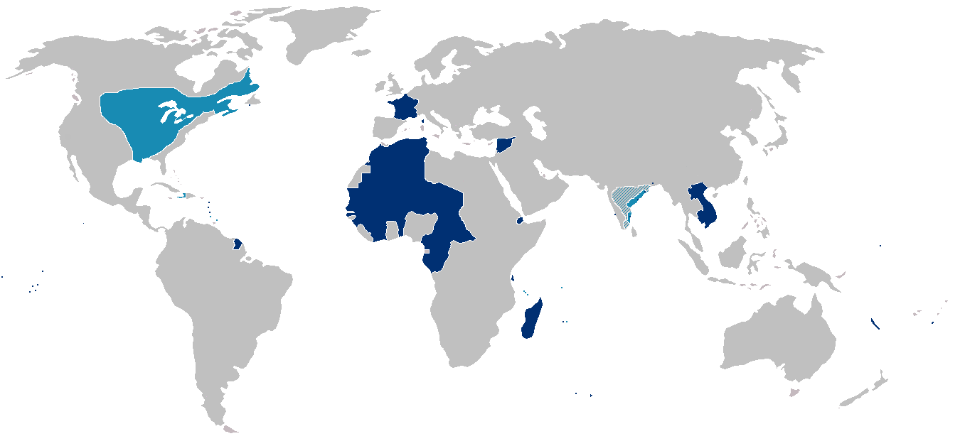
Map of the first (light blue) and second (dark blue) French colonial empires. Hatched portions mark spheres of French influence rather than possessions.
Note that the state of France's actual control over much of interior North America west and south of Great Lakes was almost purely nominal.
Licensing
| This file is licensed under the Creative Commons Attribution-Share Alike 3.0 Unported license. Subject to disclaimers. | ||
| ||
| This licensing tag was added to this file as part of the GFDL licensing update. |

|
Permission is granted to copy, distribute and/or modify this document under the terms of the GNU Free Documentation License, Version 1.2 or any later version published by the Free Software Foundation; with no Invariant Sections, no Front-Cover Texts, and no Back-Cover Texts. A copy of the license is included in the section entitled GNU Free Documentation License. Subject to disclaimers. |
Other versions

|
This historical map image could be re-created using vector graphics as an SVG file. This has several advantages; see Commons:Media for cleanup for more information. If an SVG form of this image is available, please upload it and afterwards replace this template with
{{vector version available|new image name}}.
It is recommended to name the SVG file “France colonial Empire10.svg”—then the template Vector version available (or Vva) does not need the new image name parameter. |
File history
Click on a date/time to view the file as it appeared at that time.
| Date/Time | Thumbnail | Dimensions | User | Comment | |
|---|---|---|---|---|---|
| current | 16:43, 3 March 2019 | | 1,357 × 628 (43 KB) | Rzzgn | Corrections |
| 23:43, 9 August 2011 |  | 1,357 × 628 (15 KB) | Omar-Toons | corr. oversizing | |
| 17:10, 8 August 2011 |  | 1,357 × 628 (14 KB) | Bokpasa | Tarfaya and Ifni, was part of Spain, not France | |
| 23:07, 13 June 2010 |  | 1,357 × 628 (11 KB) | Jahoe | compressed using pngout | |
| 15:29, 31 May 2010 |  | 1,357 × 628 (45 KB) | Max96 | Evened out the striping | |
| 19:14, 6 January 2009 |  | 1,357 × 628 (31 KB) | Kmusser | Reverted to version as of 20:52, 19 March 2007 | |
| 23:30, 31 December 2008 |  | 1,357 × 628 (26 KB) | The Red Hat of Pat Ferrick | Corrections. | |
| 20:52, 19 March 2007 |  | 1,357 × 628 (31 KB) | Kmusser | Changed portion of India, Siam to hatched, exaggerated and added some islands. | |
| 16:17, 14 October 2005 |  | 1,357 × 628 (24 KB) | Yug | From en:Image:France colonial Empire10.png |
File usage
The following pages on the English Wikipedia use this file (pages on other projects are not listed):
Global file usage
The following other wikis use this file:
- Usage on azb.wikipedia.org
- Usage on eo.wikipedia.org
- Usage on fa.wikipedia.org
- Usage on fr.wikipedia.org
- Politique extérieure française de 1814 à 1914
- Discussion utilisateur:Reynier
- Projet:Nouvelle-France/Brasserie Port-Royal/Archives 2
- Wikipédia:Atelier graphique/Cartes/Archives/décembre 2007
- Dates des indépendances dans l'empire colonial français
- Histoire de France
- Projet:Nouvelle-France/Brasserie Port-Royal/Archives
- Usage on ku.wikipedia.org
- Usage on mg.wikipedia.org
- Usage on mk.wikipedia.org
- Usage on pt.wikipedia.org
- Usage on sr.wikipedia.org
- Usage on ta.wikipedia.org
- Usage on ug.wikipedia.org
- Usage on zh-yue.wikipedia.org
