


Informatics Educational Institutions & Programs

Size of this preview: 600 × 600 pixels. Other resolutions: 240 × 240 pixels | 480 × 480 pixels | 768 × 768 pixels | 1,024 × 1,024 pixels | 2,048 × 2,048 pixels | 2,560 × 2,560 pixels.
Original file (2,560 × 2,560 pixels, file size: 1.86 MB, MIME type: image/png)
Summary
| Description |
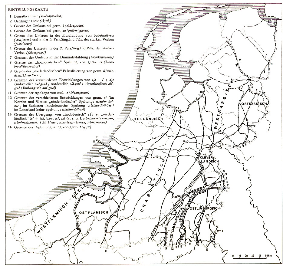
Deutsch: Darstellungskarte der niederfränkischen Dialektgruppen. Legende: = Nordniederfränkisch = Südniederfränkisch = Ostbergisch = niedersächsisches Übergangsgebiet, das verschiedentlich zum Niederfränkischen gezählt wird. |
| Date | |
| Source |
Nach Franz Petri, Helmut de Boor und Herbert Frenzel in „Die Kulturen der Niederlande und Skandinavien“, Karte S. 8, Jan Goossens „Sprachatlas des nördlichen Rheinlands und des südöstlichen Niederlands“, Band 2, Textkarte 1, und Webkarte „Einteilungskarte der niederländischen Dialekte“, welche Goossens folgt. Diese Darstellungskarte entstand in mehreren Schritten im Deutsche-Geschichte-Wiki und die entsprechenden Bearbeitungsversionen können dort eingesehen werden. |
| Author | Hardcore-Mike |
Licensing
I, the copyright holder of this work, hereby publish it under the following license:
This file is licensed under the Creative Commons Attribution-Share Alike 3.0 Unported license.
- You are free:
- to share – to copy, distribute and transmit the work
- to remix – to adapt the work
- Under the following conditions:
- attribution – You must give appropriate credit, provide a link to the license, and indicate if changes were made. You may do so in any reasonable manner, but not in any way that suggests the licensor endorses you or your use.
- share alike – If you remix, transform, or build upon the material, you must distribute your contributions under the same or compatible license as the original.
File history
Click on a date/time to view the file as it appeared at that time.
| Date/Time | Thumbnail | Dimensions | User | Comment | |
|---|---|---|---|---|---|
| current | 18:56, 19 April 2021 | | 2,560 × 2,560 (1.86 MB) | Spazzo | Position of Xanten corrected |
| 08:31, 19 April 2021 |  | 2,560 × 2,560 (1.86 MB) | Spazzo | Xanten added | |
| 08:17, 23 September 2018 |  | 2,560 × 2,560 (1.72 MB) | Spazzo | Changed Cales to Calais, added Kortrijk and Duisburg-Huckingen | |
| 21:32, 19 July 2017 |  | 2,560 × 2,560 (887 KB) | Spazzo | Grenze korrigiert | |
| 20:46, 22 March 2017 |  | 2,560 × 2,560 (837 KB) | Spazzo | Position von Duisburg und Moers korrigiert. | |
| 20:38, 22 March 2017 |  | 2,560 × 2,560 (1.27 MB) | Spazzo | Reverted to version as of 15:05, 9 May 2015 (UTC) | |
| 20:28, 22 March 2017 |  | 2,560 × 2,560 (846 KB) | Spazzo | Position von Duisburg und Moers korrigiert. | |
| 15:05, 9 May 2015 |  | 2,560 × 2,560 (1.27 MB) | MicBy67 | {{Information |Description ={{de|1={{Dateiinfo |Beschreibung = Darstellungskarte der niederfränkischen Dialektgruppen.<br /><u><big>Legende:</big></u><br /> <span style="background-color:#00DD00;"> </span> = Nordniederfränkisch<b... |
File usage
The following pages on the English Wikipedia use this file (pages on other projects are not listed):
Global file usage
The following other wikis use this file:
- Usage on af.wikipedia.org
- Usage on als.wikipedia.org
- Usage on be.wikipedia.org
- Usage on de.wikipedia.org
- Usage on fa.wikipedia.org
- Usage on frr.wikipedia.org
- Usage on fr.wikipedia.org
- Usage on fy.wikipedia.org
- Usage on hi.wikipedia.org
- Usage on id.wikipedia.org
- Usage on it.wikipedia.org
- Usage on ja.wikipedia.org
- Usage on ksh.wikipedia.org
- Usage on lb.wikipedia.org
- Usage on li.wikipedia.org
- Usage on mai.wikipedia.org
- Usage on nds-nl.wikipedia.org
- Usage on nds.wikipedia.org
- Usage on nl.wikipedia.org
- Usage on pl.wikipedia.org
- Usage on ru.wikipedia.org
- Usage on simple.wikipedia.org
- Usage on ta.wikipedia.org
- Usage on vi.wikipedia.org
- Usage on vls.wikipedia.org
- Usage on zh.wikipedia.org
