


Informatics Educational Institutions & Programs
Freudenstadt is a Landkreis (district) in the middle of Baden-Württemberg, Germany. Neighboring districts are (from north clockwise) Rastatt, Calw, Tübingen, Zollernalbkreis, Rottweil and the Ortenaukreis.
Freudenstadt | |
|---|---|
 Flag  Coat of arms | |
 | |
| Country | Germany |
| State | Baden-Württemberg |
| Adm. region | Karlsruhe |
| Capital | Freudenstadt |
| Government | |
| • District admin. | Klaus Michael Rückert (CDU) |
| Area | |
| • Total | 870.68 km2 (336.17 sq mi) |
| Population (31 December 2022)[1] | |
| • Total | 121,164 |
| • Density | 140/km2 (360/sq mi) |
| Time zone | UTC+01:00 (CET) |
| • Summer (DST) | UTC+02:00 (CEST) |
| Vehicle registration | FDS |
| Website | www |
History
The district was created in 1938 as the successor of the Oberamt Freudenstadt which dated back to 1806. In 1973 it was merged with the majority of the neighboring district of Horb, and some small parts of the districts of Wolfach and Hechingen.
Geography
The district is located in the middle part of the Black Forest mountains. The river Neckar flows through the southeast of the district.
Coat of arms
|
|
The coat of arms displays a capercaillie, which once was quite common in the area. The colors yellow and black are chosen as they are the colors of Württemberg. |
Towns and municipalities
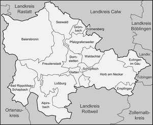
| Cities | Towns |
|---|---|
| Administrative districts | |
|
References
- ^ "Bevölkerung nach Nationalität und Geschlecht am 31. Dezember 2022" [Population by nationality and sex as of December 31, 2022] (CSV) (in German). Statistisches Landesamt Baden-Württemberg. June 2023.
External links
- Official website (German, English, French)
