


Informatics Educational Institutions & Programs


Size of this preview: 400 × 600 pixels. Other resolutions: 160 × 240 pixels | 320 × 480 pixels | 512 × 768 pixels | 1,196 × 1,794 pixels.
Original file (1,196 × 1,794 pixels, file size: 1.9 MB, MIME type: image/jpeg)
Summary
| Description |
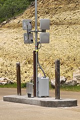
English: Radio-frequency identification installation to track vehicles coming into and leaving a gated community. One antenna on each side transmits a signal to activate the passive RFID chip affixed to the vehicle, and the other antenna receives the signal back with the encoded information from the chip. If the chip provides a valid number in the database of the controller located in the box at the base of the pole, the gate is opened. |
| Date | Taken on 26 June 2007 |
| Source | Own work |
| Author | Larry D. Moore |
| Permission (Reusing this file) |
© 2007 Larry D. Moore. Licensed under CC BY 4.0. Attribution Specification: Reuse without attribution is a violation of the license. The photographer's name and the link to the license are required. A link back to this source is requested. Example: Larry D. Moore, CC BY 4.0, Wikimedia Commons. |
| Camera location | | View this and other nearby images on: OpenStreetMap |
|---|
Licensing
Larry D. Moore, the copyright holder of this work, hereby publishes it under the following license:
This file is licensed under the Creative Commons Attribution 4.0 International license.
Attribution: Larry D. Moore
- You are free:
- to share – to copy, distribute and transmit the work
- to remix – to adapt the work
- Under the following conditions:
- attribution – You must give appropriate credit, provide a link to the license, and indicate if changes were made. You may do so in any reasonable manner, but not in any way that suggests the licensor endorses you or your use.
File history
Click on a date/time to view the file as it appeared at that time.
| Date/Time | Thumbnail | Dimensions | User | Comment | |
|---|---|---|---|---|---|
| current | 17:55, 24 March 2013 | | 1,196 × 1,794 (1.9 MB) | Nv8200pa | == {{int:filedesc}} == {{Information |Description={{en|{{w|Radio-frequency identification}} antennas to track vehicles coming into and leaving a gated community. One antenna on each side transmits a signal to activate the passive RFID chip affixed to t... |
File usage
The following pages on the English Wikipedia use this file (pages on other projects are not listed):
Global file usage
The following other wikis use this file:
- Usage on bn.wikipedia.org
- Usage on fa.wikipedia.org
- Usage on ja.wikipedia.org
- Usage on ko.wikipedia.org
- Usage on pt.wikipedia.org
- Usage on uk.wikipedia.org
- Usage on vi.wikipedia.org
- Điện tử học
- Công nghệ nano
- Vật liệu nano
- Trí tuệ nhân tạo
- Nhiên liệu sinh học
- Định luật Moore
- Mật mã lượng tử
- Lực
- Siêu dẫn nhiệt độ cao
- Tàu đệm từ
- Hiệu ứng từ nhiệt
- Thang máy vũ trụ
- Nhà thông minh
- Metamaterial
- Điện Mặt Trời
- Graphen
- Năng lượng hợp hạch
- Điểm kỳ dị công nghệ
- Điện lưới thông minh
- Du hành không gian
- Thịt trong ống nghiệm
- Vũ khí phản vật chất
- Động cơ ion
- Mạng ngữ nghĩa
- Boeing X-53 Active Aeroelastic Wing
- Diode phát sáng hữu cơ
- Công nghệ mới nổi
- Bản mẫu:Công nghệ mới nổi
- In 3D
- Danh sách công nghệ mới nổi
- Kiến trúc sinh thái
- Thành phố vòm
- Siêu vật liệu tàng hình
- Chấm lượng tử
- Internet Vạn Vật
- Truyền hình độ nét cực cao
- Độ phân giải màn hình 8K
- Công nghệ lượng tử
- Điện toán lượng tử
- Trò chơi điện tử ứng dụng hóa
- In 4D
- Dự án Avatar
- 5G
- Màn hình dẻo
View more global usage of this file.
