


Informatics Educational Institutions & Programs

Latina | |
|---|---|
| Comune di Latina | |
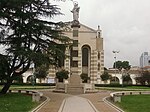
 Panorama of Latina | |
 Flag  Coat of arms | |
Location of Latina  | |
 Latina Location of Latina in Italy  Latina Latina (Lazio) | |
| Coordinates: 41°28′02″N 12°54′13″E / 41.46722°N 12.90361°E | |
| Country | Italy |
| Region | Lazio |
| Province | Latina (LT) |
| Frazioni | See list |
| Government | |
| • Mayor | Matilde Celentano (Fdl) |
| Area | |
| • Total | 277 km2 (107 sq mi) |
| Elevation | 21 m (69 ft) |
| Population (31 December 2015)[2] | |
| • Total | 125,985 |
| • Density | 450/km2 (1,200/sq mi) |
| Demonym | Latinensi |
| Time zone | UTC+1 (CET) |
| • Summer (DST) | UTC+2 (CEST) |
| Postal code | 04100, 04010, 04013 |
| Dialing code | 0773 |
| ISTAT code | 059011 |
| Patron saint | Saint Maria Goretti and St. Mark |
| Saint day | April 25, July 6 |
| Website | Official website |
Latina (Italian: [laˈtiːna] ⓘ) is the capital of the province of Latina, in the Lazio region, in Central Italy. As of 2011, the city has 126,612 inhabitants and is the second-largest city of the region, after the national capital Rome. It was founded as Littoria in 1932 under the fascist administration, when the area surrounding it which had been a swamp since antiquity was drained.
History

Although the area was first settled by the Latins, the modern city was founded by Benito Mussolini on 30 June 1932 as Littoria, named for the fascio littorio. The city was inaugurated on 18 December of the same year. Littoria was populated with settlers coming mainly from Friuli and Veneto, who formed the so-called Venetian-Pontine community (today surviving only in some peripheral boroughs). The edifices and the monuments, mainly in rationalist style, were designed by famous architects and artists such as Marcello Piacentini, Angiolo Mazzoni and Duilio Cambellotti.
In 1934 it became a provincial capital and, after World War II, renamed Latina in 1946. With the arrival of other people mostly from Lazio itself, the original Venetian-like dialect was increasingly substituted by a form of Romanesco dialect.
The city coat of arms is a blue shield with a stylized drawing of the City Hall Clock Tower in the middle, standing on a field of green, and flanked by two stalks of wheat tied at the base with a red ribbon engraved with the motto LATINA OLIM PALUS ("Latina, once a swamp") in Latin. The shield is surmounted by a mural crown.
Economy
The city has some pharmaceutical, chemical industry and a strong service sector. Latina is also an important centre for agriculture (vegetables, flowers, sugar, fruit, cheese and derivates).
The former Latina nuclear power plant has been shut down and is currently undergoing decommissioning.
Government
Frazioni
The frazioni of Latina are: Latina Lido, Latina Scalo, Borgo Bainsizza, Borgo Carso, Borgo Faiti, Borgo Grappa, Borgo Isonzo, Borgo Montello, Borgo Piave, Borgo Podgora, Borgo Sabotino, Borgo Santa Maria, Borgo San Michele, Chiesuola, and Tor Tre Ponti.
Geography
Latina is located in the Province of Latina, part of the southern section of the region of Lazio. The city is about 62 km (39 mi) south of Rome The municipality borders on Aprilia, Cisterna di Latina, Nettuno, Pontinia, Sabaudia, Sermoneta and Sezze.
Climate
Latina has a Mediterranean climate (Köppen climate classification Csa) like most of southern Italy.
| Climate data for Latina (Latina Air Base) (1991–2020) | |||||||||||||
|---|---|---|---|---|---|---|---|---|---|---|---|---|---|
| Month | Jan | Feb | Mar | Apr | May | Jun | Jul | Aug | Sep | Oct | Nov | Dec | Year |
| Record high °C (°F) | 21.4 (70.5) |
23.0 (73.4) |
24.8 (76.6) |
30.2 (86.4) |
36.0 (96.8) |
37.8 (100.0) |
39.0 (102.2) |
42.4 (108.3) |
36.6 (97.9) |
30.0 (86.0) |
26.2 (79.2) |
20.2 (68.4) |
42.4 (108.3) |
| Mean daily maximum °C (°F) | 13.3 (55.9) |
13.9 (57.0) |
16.4 (61.5) |
19.3 (66.7) |
23.8 (74.8) |
28.3 (82.9) |
31.3 (88.3) |
31.8 (89.2) |
27.3 (81.1) |
23.0 (73.4) |
18.1 (64.6) |
14.4 (57.9) |
21.8 (71.2) |
| Daily mean °C (°F) | 8.2 (46.8) |
8.6 (47.5) |
11.1 (52.0) |
13.8 (56.8) |
18.1 (64.6) |
22.4 (72.3) |
25.0 (77.0) |
25.5 (77.9) |
21.6 (70.9) |
17.7 (63.9) |
13.3 (55.9) |
9.5 (49.1) |
16.2 (61.2) |
| Mean daily minimum °C (°F) | 3.5 (38.3) |
3.5 (38.3) |
5.7 (42.3) |
8.2 (46.8) |
12.1 (53.8) |
16.2 (61.2) |
18.6 (65.5) |
19.1 (66.4) |
16.0 (60.8) |
12.4 (54.3) |
8.7 (47.7) |
4.7 (40.5) |
10.7 (51.3) |
| Record low °C (°F) | −6.6 (20.1) |
−5.0 (23.0) |
−2.8 (27.0) |
−0.4 (31.3) |
3.6 (38.5) |
7.6 (45.7) |
11.2 (52.2) |
11.8 (53.2) |
6.8 (44.2) |
2.4 (36.3) |
−1.4 (29.5) |
−7.0 (19.4) |
−7.0 (19.4) |
| Average precipitation mm (inches) | 73.49 (2.89) |
68.73 (2.71) |
69.78 (2.75) |
69.42 (2.73) |
57.67 (2.27) |
31.25 (1.23) |
20.18 (0.79) |
31.85 (1.25) |
87.70 (3.45) |
108.46 (4.27) |
124.20 (4.89) |
101.98 (4.01) |
844.71 (33.26) |
| Average precipitation days (≥ 1.0 mm) | 8.63 | 7.87 | 8.10 | 8.13 | 6.43 | 3.57 | 2.23 | 2.54 | 7.07 | 8.07 | 10.21 | 9.43 | 82.28 |
| Average relative humidity (%) | 76.17 | 73.30 | 73.29 | 73.63 | 71.88 | 69.85 | 68.51 | 68.48 | 71.44 | 75.06 | 77.63 | 77.18 | 73.03 |
| Average dew point °C (°F) | 5.06 (41.11) |
4.71 (40.48) |
7.05 (44.69) |
9.83 (49.69) |
13.43 (56.17) |
16.78 (62.20) |
18.96 (66.13) |
19.20 (66.56) |
16.59 (61.86) |
14.01 (57.22) |
10.38 (50.68) |
6.36 (43.45) |
11.86 (53.35) |
| Source: NOAA[3] | |||||||||||||
In popular culture
The Italian film My Brother Is an Only Child is set in Latina.[4]
The Amazon Prime Video original series Prisma follows the coming-of-age of a group of teenagers from Latina.[5]
People
- Manuela Arcuri, actress
- Calcutta, stage name of Edoardo d'Erme, musician and composer
- Fabrizio del Monte, racing driver
- Tiziano Ferro, pop singer
- Antonio Pennacchi, writer
- Mattia Perin, football goalkeeper
- Karin Proia, actress
- Ilaria Spada, actress
- Elena Santarelli, actress, model and television presenter
International relations
Twin towns / Sister cities
Latina is twinned with:
 Palos de la Frontera, Huelva, Andalusia, Spain
 Farroupilha, Rio Grande do Sul, Brazil
 Birkenhead, Wirral, Merseyside, England
Gallery
-
-
 The fountain in Piazza Libertà
 -
 The church of Borgo Sabotino
 -
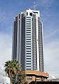 Torre Pontina, the tallest building in the city and the 11th tallest in Italy


See also
- Latina railway station
- Latina Calcio 1932 – a football club
References
- ^ "Superficie di Comuni Province e Regioni italiane al 9 ottobre 2011". Italian National Institute of Statistics. Retrieved 16 March 2019.
- ^ "Popolazione Residente al 1° Gennaio 2018". Italian National Institute of Statistics. Retrieved 16 March 2019.
- ^ "World Meteorological Organization Climate Normals for 1991-2020 — Latina". National Oceanic and Atmospheric Administration. Retrieved February 3, 2024.
- ^ Weissberg, Jay (2007-05-18). "My Brother Is an Only Child Review". variety.com. Retrieved 18 May 2007.
- ^ "Prisma". Amazon Prime Video. Amazon Studios. Retrieved 5 December 2022.
External links
- Official website
- Ofteland, Hanne Storm (2002). "Littoria" (PDF). Institute for Art History, University of Oslo. Archived from the original (PDF) on 7 September 2008. Retrieved 5 February 2010.
| International | |
|---|---|
| National | |
| Geographic | |
| Other | |
