LabLynx Wiki

Contents
 Cypress Island from Rosario Strait | |
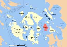 Cypress Island in the San Juan Islands | |
| Geography | |
|---|---|
| Location | Salish Sea |
| Coordinates | 48°34′27″N 122°42′20″W / 48.57417°N 122.70556°W |
| Area | 8.6 sq mi (22 km2) |
| Length | 4.75 mi (7.64 km) |
| Width | 3.5 mi (5.6 km) |
| Highest elevation | 1,525 ft (464.8 m) |
| Administration | |
United States | |
| State | Washington |
| County | Skagit County |
| Demographics | |
| Population | 40 (2000) |


Cypress Island is the westernmost part of Skagit County, Washington, and is about halfway between the mainland and offshore San Juan County.
LIMSpec Wiki
Contents
 Cypress Island from Rosario Strait | |
 Cypress Island in the San Juan Islands | |
| Geography | |
|---|---|
| Location | Salish Sea |
| Coordinates | 48°34′27″N 122°42′20″W / 48.57417°N 122.70556°W |
| Area | 8.6 sq mi (22 km2) |
| Length | 4.75 mi (7.64 km) |
| Width | 3.5 mi (5.6 km) |
| Highest elevation | 1,525 ft (464.8 m) |
| Administration | |
United States | |
| State | Washington |
| County | Skagit County |
| Demographics | |
| Population | 40 (2000) |


Cypress Island is the westernmost part of Skagit County, Washington, and is about halfway between the mainland and offshore San Juan County.
Bioinformatics Wiki
Contents
 Cypress Island from Rosario Strait | |
 Cypress Island in the San Juan Islands | |
| Geography | |
|---|---|
| Location | Salish Sea |
| Coordinates | 48°34′27″N 122°42′20″W / 48.57417°N 122.70556°W |
| Area | 8.6 sq mi (22 km2) |
| Length | 4.75 mi (7.64 km) |
| Width | 3.5 mi (5.6 km) |
| Highest elevation | 1,525 ft (464.8 m) |
| Administration | |
United States | |
| State | Washington |
| County | Skagit County |
| Demographics | |
| Population | 40 (2000) |


Cypress Island is the westernmost part of Skagit County, Washington, and is about halfway between the mainland and offshore San Juan County.
IHE Wiki

Contents
 Cypress Island from Rosario Strait | |
 Cypress Island in the San Juan Islands | |
| Geography | |
|---|---|
| Location | Salish Sea |
| Coordinates | 48°34′27″N 122°42′20″W / 48.57417°N 122.70556°W |
| Area | 8.6 sq mi (22 km2) |
| Length | 4.75 mi (7.64 km) |
| Width | 3.5 mi (5.6 km) |
| Highest elevation | 1,525 ft (464.8 m) |
| Administration | |
United States | |
| State | Washington |
| County | Skagit County |
| Demographics | |
| Population | 40 (2000) |


Cypress Island is the westernmost part of Skagit County, Washington, and is about halfway between the mainland and offshore San Juan County.
HL7 Wiki
Contents
 Cypress Island from Rosario Strait | |
 Cypress Island in the San Juan Islands | |
| Geography | |
|---|---|
| Location | Salish Sea |
| Coordinates | 48°34′27″N 122°42′20″W / 48.57417°N 122.70556°W |
| Area | 8.6 sq mi (22 km2) |
| Length | 4.75 mi (7.64 km) |
| Width | 3.5 mi (5.6 km) |
| Highest elevation | 1,525 ft (464.8 m) |
| Administration | |
United States | |
| State | Washington |
| County | Skagit County |
| Demographics | |
| Population | 40 (2000) |


Cypress Island is the westernmost part of Skagit County, Washington, and is about halfway between the mainland and offshore San Juan County.
Clinfowiki

Contents
 Cypress Island from Rosario Strait | |
 Cypress Island in the San Juan Islands | |
| Geography | |
|---|---|
| Location | Salish Sea |
| Coordinates | 48°34′27″N 122°42′20″W / 48.57417°N 122.70556°W |
| Area | 8.6 sq mi (22 km2) |
| Length | 4.75 mi (7.64 km) |
| Width | 3.5 mi (5.6 km) |
| Highest elevation | 1,525 ft (464.8 m) |
| Administration | |
United States | |
| State | Washington |
| County | Skagit County |
| Demographics | |
| Population | 40 (2000) |


Cypress Island is the westernmost part of Skagit County, Washington, and is about halfway between the mainland and offshore San Juan County.
OpenWetWare

Contents
 Cypress Island from Rosario Strait | |
 Cypress Island in the San Juan Islands | |
| Geography | |
|---|---|
| Location | Salish Sea |
| Coordinates | 48°34′27″N 122°42′20″W / 48.57417°N 122.70556°W |
| Area | 8.6 sq mi (22 km2) |
| Length | 4.75 mi (7.64 km) |
| Width | 3.5 mi (5.6 km) |
| Highest elevation | 1,525 ft (464.8 m) |
| Administration | |
United States | |
| State | Washington |
| County | Skagit County |
| Demographics | |
| Population | 40 (2000) |


Cypress Island is the westernmost part of Skagit County, Washington, and is about halfway between the mainland and offshore San Juan County.
Statistical Genetics Wiki
Contents
 Cypress Island from Rosario Strait | |
 Cypress Island in the San Juan Islands | |
| Geography | |
|---|---|
| Location | Salish Sea |
| Coordinates | 48°34′27″N 122°42′20″W / 48.57417°N 122.70556°W |
| Area | 8.6 sq mi (22 km2) |
| Length | 4.75 mi (7.64 km) |
| Width | 3.5 mi (5.6 km) |
| Highest elevation | 1,525 ft (464.8 m) |
| Administration | |
United States | |
| State | Washington |
| County | Skagit County |
| Demographics | |
| Population | 40 (2000) |


Cypress Island is the westernmost part of Skagit County, Washington, and is about halfway between the mainland and offshore San Juan County.
Cloud-Standards.org

Contents
 Cypress Island from Rosario Strait | |
 Cypress Island in the San Juan Islands | |
| Geography | |
|---|---|
| Location | Salish Sea |
| Coordinates | 48°34′27″N 122°42′20″W / 48.57417°N 122.70556°W |
| Area | 8.6 sq mi (22 km2) |
| Length | 4.75 mi (7.64 km) |
| Width | 3.5 mi (5.6 km) |
| Highest elevation | 1,525 ft (464.8 m) |
| Administration | |
United States | |
| State | Washington |
| County | Skagit County |
| Demographics | |
| Population | 40 (2000) |


Cypress Island is the westernmost part of Skagit County, Washington, and is about halfway between the mainland and offshore San Juan County.
WikiBooks

Contents
 Cypress Island from Rosario Strait | |
 Cypress Island in the San Juan Islands | |
| Geography | |
|---|---|
| Location | Salish Sea |
| Coordinates | 48°34′27″N 122°42′20″W / 48.57417°N 122.70556°W |
| Area | 8.6 sq mi (22 km2) |
| Length | 4.75 mi (7.64 km) |
| Width | 3.5 mi (5.6 km) |
| Highest elevation | 1,525 ft (464.8 m) |
| Administration | |
United States | |
| State | Washington |
| County | Skagit County |
| Demographics | |
| Population | 40 (2000) |


Cypress Island is the westernmost part of Skagit County, Washington, and is about halfway between the mainland and offshore San Juan County.
LIMSwiki

Contents
 Cypress Island from Rosario Strait | |
 Cypress Island in the San Juan Islands | |
| Geography | |
|---|---|
| Location | Salish Sea |
| Coordinates | 48°34′27″N 122°42′20″W / 48.57417°N 122.70556°W |
| Area | 8.6 sq mi (22 km2) |
| Length | 4.75 mi (7.64 km) |
| Width | 3.5 mi (5.6 km) |
| Highest elevation | 1,525 ft (464.8 m) |
| Administration | |
United States | |
| State | Washington |
| County | Skagit County |
| Demographics | |
| Population | 40 (2000) |


Cypress Island is the westernmost part of Skagit County, Washington, and is about halfway between the mainland and offshore San Juan County.
Wikiversity

Contents
 Cypress Island from Rosario Strait | |
 Cypress Island in the San Juan Islands | |
| Geography | |
|---|---|
| Location | Salish Sea |
| Coordinates | 48°34′27″N 122°42′20″W / 48.57417°N 122.70556°W |
| Area | 8.6 sq mi (22 km2) |
| Length | 4.75 mi (7.64 km) |
| Width | 3.5 mi (5.6 km) |
| Highest elevation | 1,525 ft (464.8 m) |
| Administration | |
United States | |
| State | Washington |
| County | Skagit County |
| Demographics | |
| Population | 40 (2000) |


Cypress Island is the westernmost part of Skagit County, Washington, and is about halfway between the mainland and offshore San Juan County.
Wikipedia

Contents
 Cypress Island from Rosario Strait | |
 Cypress Island in the San Juan Islands | |
| Geography | |
|---|---|
| Location | Salish Sea |
| Coordinates | 48°34′27″N 122°42′20″W / 48.57417°N 122.70556°W |
| Area | 8.6 sq mi (22 km2) |
| Length | 4.75 mi (7.64 km) |
| Width | 3.5 mi (5.6 km) |
| Highest elevation | 1,525 ft (464.8 m) |
| Administration | |
United States | |
| State | Washington |
| County | Skagit County |
| Demographics | |
| Population | 40 (2000) |


Cypress Island is the westernmost part of Skagit County, Washington, and is about halfway between the mainland and offshore San Juan County.


