LabLynx Wiki

Contents
Larsen Ice Shelf | |
|---|---|
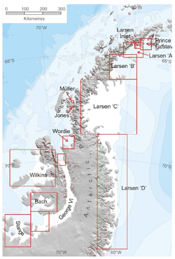
 Larsen Ice Shelves A, B, C, and D | |
| Coordinates: 67°30′S 62°30′W / 67.500°S 62.500°W | |
| Location | Antarctica |
| Part of | Antarctic Peninsula |
| Offshore water bodies | Weddell Sea |
| Etymology | Carl Anton Larsen, captain of the vessel Jason |
| Area | |
| • Total | 26,000 square miles (67,000 km2) |
The Larsen Ice Shelf is a long ice shelf in the northwest part of the Weddell Sea, extending along the east coast of the Antarctic Peninsula[1] from Cape Longing to Smith Peninsula.
LIMSpec Wiki

Contents
Larsen Ice Shelf | |
|---|---|
 Larsen Ice Shelves A, B, C, and D | |
| Coordinates: 67°30′S 62°30′W / 67.500°S 62.500°W | |
| Location | Antarctica |
| Part of | Antarctic Peninsula |
| Offshore water bodies | Weddell Sea |
| Etymology | Carl Anton Larsen, captain of the vessel Jason |
| Area | |
| • Total | 26,000 square miles (67,000 km2) |
The Larsen Ice Shelf is a long ice shelf in the northwest part of the Weddell Sea, extending along the east coast of the Antarctic Peninsula[1] from Cape Longing to Smith Peninsula.
Bioinformatics Wiki

Contents
Larsen Ice Shelf | |
|---|---|
 Larsen Ice Shelves A, B, C, and D | |
| Coordinates: 67°30′S 62°30′W / 67.500°S 62.500°W | |
| Location | Antarctica |
| Part of | Antarctic Peninsula |
| Offshore water bodies | Weddell Sea |
| Etymology | Carl Anton Larsen, captain of the vessel Jason |
| Area | |
| • Total | 26,000 square miles (67,000 km2) |
The Larsen Ice Shelf is a long ice shelf in the northwest part of the Weddell Sea, extending along the east coast of the Antarctic Peninsula[1] from Cape Longing to Smith Peninsula.
IHE Wiki

Contents
Larsen Ice Shelf | |
|---|---|
 Larsen Ice Shelves A, B, C, and D | |
| Coordinates: 67°30′S 62°30′W / 67.500°S 62.500°W | |
| Location | Antarctica |
| Part of | Antarctic Peninsula |
| Offshore water bodies | Weddell Sea |
| Etymology | Carl Anton Larsen, captain of the vessel Jason |
| Area | |
| • Total | 26,000 square miles (67,000 km2) |
The Larsen Ice Shelf is a long ice shelf in the northwest part of the Weddell Sea, extending along the east coast of the Antarctic Peninsula[1] from Cape Longing to Smith Peninsula.
HL7 Wiki

Contents
Larsen Ice Shelf | |
|---|---|
 Larsen Ice Shelves A, B, C, and D | |
| Coordinates: 67°30′S 62°30′W / 67.500°S 62.500°W | |
| Location | Antarctica |
| Part of | Antarctic Peninsula |
| Offshore water bodies | Weddell Sea |
| Etymology | Carl Anton Larsen, captain of the vessel Jason |
| Area | |
| • Total | 26,000 square miles (67,000 km2) |
The Larsen Ice Shelf is a long ice shelf in the northwest part of the Weddell Sea, extending along the east coast of the Antarctic Peninsula[1] from Cape Longing to Smith Peninsula.
Clinfowiki

Contents
Larsen Ice Shelf | |
|---|---|
 Larsen Ice Shelves A, B, C, and D | |
| Coordinates: 67°30′S 62°30′W / 67.500°S 62.500°W | |
| Location | Antarctica |
| Part of | Antarctic Peninsula |
| Offshore water bodies | Weddell Sea |
| Etymology | Carl Anton Larsen, captain of the vessel Jason |
| Area | |
| • Total | 26,000 square miles (67,000 km2) |
The Larsen Ice Shelf is a long ice shelf in the northwest part of the Weddell Sea, extending along the east coast of the Antarctic Peninsula[1] from Cape Longing to Smith Peninsula.
OpenWetWare

Contents
Larsen Ice Shelf | |
|---|---|
 Larsen Ice Shelves A, B, C, and D | |
| Coordinates: 67°30′S 62°30′W / 67.500°S 62.500°W | |
| Location | Antarctica |
| Part of | Antarctic Peninsula |
| Offshore water bodies | Weddell Sea |
| Etymology | Carl Anton Larsen, captain of the vessel Jason |
| Area | |
| • Total | 26,000 square miles (67,000 km2) |
The Larsen Ice Shelf is a long ice shelf in the northwest part of the Weddell Sea, extending along the east coast of the Antarctic Peninsula[1] from Cape Longing to Smith Peninsula.
Statistical Genetics Wiki

Contents
Larsen Ice Shelf | |
|---|---|
 Larsen Ice Shelves A, B, C, and D | |
| Coordinates: 67°30′S 62°30′W / 67.500°S 62.500°W | |
| Location | Antarctica |
| Part of | Antarctic Peninsula |
| Offshore water bodies | Weddell Sea |
| Etymology | Carl Anton Larsen, captain of the vessel Jason |
| Area | |
| • Total | 26,000 square miles (67,000 km2) |
The Larsen Ice Shelf is a long ice shelf in the northwest part of the Weddell Sea, extending along the east coast of the Antarctic Peninsula[1] from Cape Longing to Smith Peninsula.
Cloud-Standards.org

Contents
Larsen Ice Shelf | |
|---|---|
 Larsen Ice Shelves A, B, C, and D | |
| Coordinates: 67°30′S 62°30′W / 67.500°S 62.500°W | |
| Location | Antarctica |
| Part of | Antarctic Peninsula |
| Offshore water bodies | Weddell Sea |
| Etymology | Carl Anton Larsen, captain of the vessel Jason |
| Area | |
| • Total | 26,000 square miles (67,000 km2) |
The Larsen Ice Shelf is a long ice shelf in the northwest part of the Weddell Sea, extending along the east coast of the Antarctic Peninsula[1] from Cape Longing to Smith Peninsula.
WikiBooks

Contents
Larsen Ice Shelf | |
|---|---|
 Larsen Ice Shelves A, B, C, and D | |
| Coordinates: 67°30′S 62°30′W / 67.500°S 62.500°W | |
| Location | Antarctica |
| Part of | Antarctic Peninsula |
| Offshore water bodies | Weddell Sea |
| Etymology | Carl Anton Larsen, captain of the vessel Jason |
| Area | |
| • Total | 26,000 square miles (67,000 km2) |
The Larsen Ice Shelf is a long ice shelf in the northwest part of the Weddell Sea, extending along the east coast of the Antarctic Peninsula[1] from Cape Longing to Smith Peninsula.
LIMSwiki

Contents
Larsen Ice Shelf | |
|---|---|
 Larsen Ice Shelves A, B, C, and D | |
| Coordinates: 67°30′S 62°30′W / 67.500°S 62.500°W | |
| Location | Antarctica |
| Part of | Antarctic Peninsula |
| Offshore water bodies | Weddell Sea |
| Etymology | Carl Anton Larsen, captain of the vessel Jason |
| Area | |
| • Total | 26,000 square miles (67,000 km2) |
The Larsen Ice Shelf is a long ice shelf in the northwest part of the Weddell Sea, extending along the east coast of the Antarctic Peninsula[1] from Cape Longing to Smith Peninsula.
Wikiversity

Contents
Larsen Ice Shelf | |
|---|---|
 Larsen Ice Shelves A, B, C, and D | |
| Coordinates: 67°30′S 62°30′W / 67.500°S 62.500°W | |
| Location | Antarctica |
| Part of | Antarctic Peninsula |
| Offshore water bodies | Weddell Sea |
| Etymology | Carl Anton Larsen, captain of the vessel Jason |
| Area | |
| • Total | 26,000 square miles (67,000 km2) |
The Larsen Ice Shelf is a long ice shelf in the northwest part of the Weddell Sea, extending along the east coast of the Antarctic Peninsula[1] from Cape Longing to Smith Peninsula.
Wikipedia

Contents
Larsen Ice Shelf | |
|---|---|
 Larsen Ice Shelves A, B, C, and D | |
| Coordinates: 67°30′S 62°30′W / 67.500°S 62.500°W | |
| Location | Antarctica |
| Part of | Antarctic Peninsula |
| Offshore water bodies | Weddell Sea |
| Etymology | Carl Anton Larsen, captain of the vessel Jason |
| Area | |
| • Total | 26,000 square miles (67,000 km2) |
The Larsen Ice Shelf is a long ice shelf in the northwest part of the Weddell Sea, extending along the east coast of the Antarctic Peninsula[1] from Cape Longing to Smith Peninsula.


