LabLynx Wiki
Manhattan, Kansas | |
|---|---|
City and County seat | |
 Riley County Courthouse (2005) | |
| Nickname(s): | |
 Location within Riley County and Kansas | |
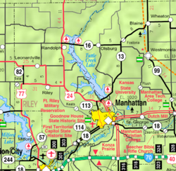 | |
| Coordinates: 39°11′19″N 96°36′17″W / 39.18861°N 96.60472°W[3] | |
| Country | United States |
| State | Kansas |
| Counties | Riley, Pottawatomie |
| Founded | 1855 |
| Incorporated | 1857 |
| Government | |
| • Type | Commission-Manager |
| • Mayor | Mark Hatesohl [citation needed] |
| Area | |
| • City and County seat | 19.91 sq mi (51.56 km2) |
| • Land | 19.85 sq mi (51.40 km2) |
| • Water | 0.06 sq mi (0.16 km2) |
| • Metro | 18.88 sq mi (48.89 km2) |
| Elevation | 1,056 ft (322 m) |
| Population | |
| • City and County seat | 54,100 |
| • Density | 2,700/sq mi (1,000/km2) |
| Time zone | UTC−6 (CST) |
| • Summer (DST) | UTC−5 (CDT) |
| ZIP Codes | 66502–66503, 66505–66506 |
| Area code | 785 |
| FIPS code | 20-44250 |
| GNIS ID | 485618[3] |
| Website | cityofmhk.com |
LIMSpec Wiki
Manhattan, Kansas | |
|---|---|
City and County seat | |
 Riley County Courthouse (2005) | |
| Nickname(s): | |
 Location within Riley County and Kansas | |
 | |
| Coordinates: 39°11′19″N 96°36′17″W / 39.18861°N 96.60472°W[3] | |
| Country | United States |
| State | Kansas |
| Counties | Riley, Pottawatomie |
| Founded | 1855 |
| Incorporated | 1857 |
| Government | |
| • Type | Commission-Manager |
| • Mayor | Mark Hatesohl [citation needed] |
| Area | |
| • City and County seat | 19.91 sq mi (51.56 km2) |
| • Land | 19.85 sq mi (51.40 km2) |
| • Water | 0.06 sq mi (0.16 km2) |
| • Metro | 18.88 sq mi (48.89 km2) |
| Elevation | 1,056 ft (322 m) |
| Population | |
| • City and County seat | 54,100 |
| • Density | 2,700/sq mi (1,000/km2) |
| Time zone | UTC−6 (CST) |
| • Summer (DST) | UTC−5 (CDT) |
| ZIP Codes | 66502–66503, 66505–66506 |
| Area code | 785 |
| FIPS code | 20-44250 |
| GNIS ID | 485618[3] |
| Website | cityofmhk.com |
Bioinformatics Wiki
Manhattan, Kansas | |
|---|---|
City and County seat | |
 Riley County Courthouse (2005) | |
| Nickname(s): | |
 Location within Riley County and Kansas | |
 | |
| Coordinates: 39°11′19″N 96°36′17″W / 39.18861°N 96.60472°W[3] | |
| Country | United States |
| State | Kansas |
| Counties | Riley, Pottawatomie |
| Founded | 1855 |
| Incorporated | 1857 |
| Government | |
| • Type | Commission-Manager |
| • Mayor | Mark Hatesohl [citation needed] |
| Area | |
| • City and County seat | 19.91 sq mi (51.56 km2) |
| • Land | 19.85 sq mi (51.40 km2) |
| • Water | 0.06 sq mi (0.16 km2) |
| • Metro | 18.88 sq mi (48.89 km2) |
| Elevation | 1,056 ft (322 m) |
| Population | |
| • City and County seat | 54,100 |
| • Density | 2,700/sq mi (1,000/km2) |
| Time zone | UTC−6 (CST) |
| • Summer (DST) | UTC−5 (CDT) |
| ZIP Codes | 66502–66503, 66505–66506 |
| Area code | 785 |
| FIPS code | 20-44250 |
| GNIS ID | 485618[3] |
| Website | cityofmhk.com |
IHE Wiki
Manhattan, Kansas | |
|---|---|
City and County seat | |
 Riley County Courthouse (2005) | |
| Nickname(s): | |
 Location within Riley County and Kansas | |
 | |
| Coordinates: 39°11′19″N 96°36′17″W / 39.18861°N 96.60472°W[3] | |
| Country | United States |
| State | Kansas |
| Counties | Riley, Pottawatomie |
| Founded | 1855 |
| Incorporated | 1857 |
| Government | |
| • Type | Commission-Manager |
| • Mayor | Mark Hatesohl [citation needed] |
| Area | |
| • City and County seat | 19.91 sq mi (51.56 km2) |
| • Land | 19.85 sq mi (51.40 km2) |
| • Water | 0.06 sq mi (0.16 km2) |
| • Metro | 18.88 sq mi (48.89 km2) |
| Elevation | 1,056 ft (322 m) |
| Population | |
| • City and County seat | 54,100 |
| • Density | 2,700/sq mi (1,000/km2) |
| Time zone | UTC−6 (CST) |
| • Summer (DST) | UTC−5 (CDT) |
| ZIP Codes | 66502–66503, 66505–66506 |
| Area code | 785 |
| FIPS code | 20-44250 |
| GNIS ID | 485618[3] |
| Website | cityofmhk.com |
HL7 Wiki
Manhattan, Kansas | |
|---|---|
City and County seat | |
 Riley County Courthouse (2005) | |
| Nickname(s): | |
 Location within Riley County and Kansas | |
 | |
| Coordinates: 39°11′19″N 96°36′17″W / 39.18861°N 96.60472°W[3] | |
| Country | United States |
| State | Kansas |
| Counties | Riley, Pottawatomie |
| Founded | 1855 |
| Incorporated | 1857 |
| Government | |
| • Type | Commission-Manager |
| • Mayor | Mark Hatesohl [citation needed] |
| Area | |
| • City and County seat | 19.91 sq mi (51.56 km2) |
| • Land | 19.85 sq mi (51.40 km2) |
| • Water | 0.06 sq mi (0.16 km2) |
| • Metro | 18.88 sq mi (48.89 km2) |
| Elevation | 1,056 ft (322 m) |
| Population | |
| • City and County seat | 54,100 |
| • Density | 2,700/sq mi (1,000/km2) |
| Time zone | UTC−6 (CST) |
| • Summer (DST) | UTC−5 (CDT) |
| ZIP Codes | 66502–66503, 66505–66506 |
| Area code | 785 |
| FIPS code | 20-44250 |
| GNIS ID | 485618[3] |
| Website | cityofmhk.com |
Clinfowiki

Manhattan, Kansas | |
|---|---|
City and County seat | |
 Riley County Courthouse (2005) | |
| Nickname(s): | |
 Location within Riley County and Kansas | |
 | |
| Coordinates: 39°11′19″N 96°36′17″W / 39.18861°N 96.60472°W[3] | |
| Country | United States |
| State | Kansas |
| Counties | Riley, Pottawatomie |
| Founded | 1855 |
| Incorporated | 1857 |
| Government | |
| • Type | Commission-Manager |
| • Mayor | Mark Hatesohl [citation needed] |
| Area | |
| • City and County seat | 19.91 sq mi (51.56 km2) |
| • Land | 19.85 sq mi (51.40 km2) |
| • Water | 0.06 sq mi (0.16 km2) |
| • Metro | 18.88 sq mi (48.89 km2) |
| Elevation | 1,056 ft (322 m) |
| Population | |
| • City and County seat | 54,100 |
| • Density | 2,700/sq mi (1,000/km2) |
| Time zone | UTC−6 (CST) |
| • Summer (DST) | UTC−5 (CDT) |
| ZIP Codes | 66502–66503, 66505–66506 |
| Area code | 785 |
| FIPS code | 20-44250 |
| GNIS ID | 485618[3] |
| Website | cityofmhk.com |
OpenWetWare
Manhattan, Kansas | |
|---|---|
City and County seat | |
 Riley County Courthouse (2005) | |
| Nickname(s): | |
 Location within Riley County and Kansas | |
 | |
| Coordinates: 39°11′19″N 96°36′17″W / 39.18861°N 96.60472°W[3] | |
| Country | United States |
| State | Kansas |
| Counties | Riley, Pottawatomie |
| Founded | 1855 |
| Incorporated | 1857 |
| Government | |
| • Type | Commission-Manager |
| • Mayor | Mark Hatesohl [citation needed] |
| Area | |
| • City and County seat | 19.91 sq mi (51.56 km2) |
| • Land | 19.85 sq mi (51.40 km2) |
| • Water | 0.06 sq mi (0.16 km2) |
| • Metro | 18.88 sq mi (48.89 km2) |
| Elevation | 1,056 ft (322 m) |
| Population | |
| • City and County seat | 54,100 |
| • Density | 2,700/sq mi (1,000/km2) |
| Time zone | UTC−6 (CST) |
| • Summer (DST) | UTC−5 (CDT) |
| ZIP Codes | 66502–66503, 66505–66506 |
| Area code | 785 |
| FIPS code | 20-44250 |
| GNIS ID | 485618[3] |
| Website | cityofmhk.com |
Statistical Genetics Wiki
Manhattan, Kansas | |
|---|---|
City and County seat | |
 Riley County Courthouse (2005) | |
| Nickname(s): | |
 Location within Riley County and Kansas | |
 | |
| Coordinates: 39°11′19″N 96°36′17″W / 39.18861°N 96.60472°W[3] | |
| Country | United States |
| State | Kansas |
| Counties | Riley, Pottawatomie |
| Founded | 1855 |
| Incorporated | 1857 |
| Government | |
| • Type | Commission-Manager |
| • Mayor | Mark Hatesohl [citation needed] |
| Area | |
| • City and County seat | 19.91 sq mi (51.56 km2) |
| • Land | 19.85 sq mi (51.40 km2) |
| • Water | 0.06 sq mi (0.16 km2) |
| • Metro | 18.88 sq mi (48.89 km2) |
| Elevation | 1,056 ft (322 m) |
| Population | |
| • City and County seat | 54,100 |
| • Density | 2,700/sq mi (1,000/km2) |
| Time zone | UTC−6 (CST) |
| • Summer (DST) | UTC−5 (CDT) |
| ZIP Codes | 66502–66503, 66505–66506 |
| Area code | 785 |
| FIPS code | 20-44250 |
| GNIS ID | 485618[3] |
| Website | cityofmhk.com |
Cloud-Standards.org

Manhattan, Kansas | |
|---|---|
City and County seat | |
 Riley County Courthouse (2005) | |
| Nickname(s): | |
 Location within Riley County and Kansas | |
 | |
| Coordinates: 39°11′19″N 96°36′17″W / 39.18861°N 96.60472°W[3] | |
| Country | United States |
| State | Kansas |
| Counties | Riley, Pottawatomie |
| Founded | 1855 |
| Incorporated | 1857 |
| Government | |
| • Type | Commission-Manager |
| • Mayor | Mark Hatesohl [citation needed] |
| Area | |
| • City and County seat | 19.91 sq mi (51.56 km2) |
| • Land | 19.85 sq mi (51.40 km2) |
| • Water | 0.06 sq mi (0.16 km2) |
| • Metro | 18.88 sq mi (48.89 km2) |
| Elevation | 1,056 ft (322 m) |
| Population | |
| • City and County seat | 54,100 |
| • Density | 2,700/sq mi (1,000/km2) |
| Time zone | UTC−6 (CST) |
| • Summer (DST) | UTC−5 (CDT) |
| ZIP Codes | 66502–66503, 66505–66506 |
| Area code | 785 |
| FIPS code | 20-44250 |
| GNIS ID | 485618[3] |
| Website | cityofmhk.com |
WikiBooks

Manhattan, Kansas | |
|---|---|
City and County seat | |
 Riley County Courthouse (2005) | |
| Nickname(s): | |
 Location within Riley County and Kansas | |
 | |
| Coordinates: 39°11′19″N 96°36′17″W / 39.18861°N 96.60472°W[3] | |
| Country | United States |
| State | Kansas |
| Counties | Riley, Pottawatomie |
| Founded | 1855 |
| Incorporated | 1857 |
| Government | |
| • Type | Commission-Manager |
| • Mayor | Mark Hatesohl [citation needed] |
| Area | |
| • City and County seat | 19.91 sq mi (51.56 km2) |
| • Land | 19.85 sq mi (51.40 km2) |
| • Water | 0.06 sq mi (0.16 km2) |
| • Metro | 18.88 sq mi (48.89 km2) |
| Elevation | 1,056 ft (322 m) |
| Population | |
| • City and County seat | 54,100 |
| • Density | 2,700/sq mi (1,000/km2) |
| Time zone | UTC−6 (CST) |
| • Summer (DST) | UTC−5 (CDT) |
| ZIP Codes | 66502–66503, 66505–66506 |
| Area code | 785 |
| FIPS code | 20-44250 |
| GNIS ID | 485618[3] |
| Website | cityofmhk.com |
LIMSwiki
Manhattan, Kansas | |
|---|---|
City and County seat | |
 Riley County Courthouse (2005) | |
| Nickname(s): | |
 Location within Riley County and Kansas | |
 | |
| Coordinates: 39°11′19″N 96°36′17″W / 39.18861°N 96.60472°W[3] | |
| Country | United States |
| State | Kansas |
| Counties | Riley, Pottawatomie |
| Founded | 1855 |
| Incorporated | 1857 |
| Government | |
| • Type | Commission-Manager |
| • Mayor | Mark Hatesohl [citation needed] |
| Area | |
| • City and County seat | 19.91 sq mi (51.56 km2) |
| • Land | 19.85 sq mi (51.40 km2) |
| • Water | 0.06 sq mi (0.16 km2) |
| • Metro | 18.88 sq mi (48.89 km2) |
| Elevation | 1,056 ft (322 m) |
| Population | |
| • City and County seat | 54,100 |
| • Density | 2,700/sq mi (1,000/km2) |
| Time zone | UTC−6 (CST) |
| • Summer (DST) | UTC−5 (CDT) |
| ZIP Codes | 66502–66503, 66505–66506 |
| Area code | 785 |
| FIPS code | 20-44250 |
| GNIS ID | 485618[3] |
| Website | cityofmhk.com |
Wikiversity
Manhattan, Kansas | |
|---|---|
City and County seat | |
 Riley County Courthouse (2005) | |
| Nickname(s): | |
 Location within Riley County and Kansas | |
 | |
| Coordinates: 39°11′19″N 96°36′17″W / 39.18861°N 96.60472°W[3] | |
| Country | United States |
| State | Kansas |
| Counties | Riley, Pottawatomie |
| Founded | 1855 |
| Incorporated | 1857 |
| Government | |
| • Type | Commission-Manager |
| • Mayor | Mark Hatesohl [citation needed] |
| Area | |
| • City and County seat | 19.91 sq mi (51.56 km2) |
| • Land | 19.85 sq mi (51.40 km2) |
| • Water | 0.06 sq mi (0.16 km2) |
| • Metro | 18.88 sq mi (48.89 km2) |
| Elevation | 1,056 ft (322 m) |
| Population | |
| • City and County seat | 54,100 |
| • Density | 2,700/sq mi (1,000/km2) |
| Time zone | UTC−6 (CST) |
| • Summer (DST) | UTC−5 (CDT) |
| ZIP Codes | 66502–66503, 66505–66506 |
| Area code | 785 |
| FIPS code | 20-44250 |
| GNIS ID | 485618[3] |
| Website | cityofmhk.com |
Wikipedia
Manhattan, Kansas | |
|---|---|
City and County seat | |
 Riley County Courthouse (2005) | |
| Nickname(s): | |
 Location within Riley County and Kansas | |
 | |
| Coordinates: 39°11′19″N 96°36′17″W / 39.18861°N 96.60472°W[3] | |
| Country | United States |
| State | Kansas |
| Counties | Riley, Pottawatomie |
| Founded | 1855 |
| Incorporated | 1857 |
| Government | |
| • Type | Commission-Manager |
| • Mayor | Mark Hatesohl [citation needed] |
| Area | |
| • City and County seat | 19.91 sq mi (51.56 km2) |
| • Land | 19.85 sq mi (51.40 km2) |
| • Water | 0.06 sq mi (0.16 km2) |
| • Metro | 18.88 sq mi (48.89 km2) |
| Elevation | 1,056 ft (322 m) |
| Population | |
| • City and County seat | 54,100 |
| • Density | 2,700/sq mi (1,000/km2) |
| Time zone | UTC−6 (CST) |
| • Summer (DST) | UTC−5 (CDT) |
| ZIP Codes | 66502–66503, 66505–66506 |
| Area code | 785 |
| FIPS code | 20-44250 |
| GNIS ID | 485618[3] |
| Website | cityofmhk.com |


