


Informatics Educational Institutions & Programs

Size of this PNG preview of this SVG file: 533 × 600 pixels. Other resolutions: 213 × 240 pixels | 426 × 480 pixels | 682 × 768 pixels | 910 × 1,024 pixels | 1,820 × 2,048 pixels | 1,125 × 1,266 pixels.
Original file (SVG file, nominally 1,125 × 1,266 pixels, file size: 1.79 MB)
| Description |
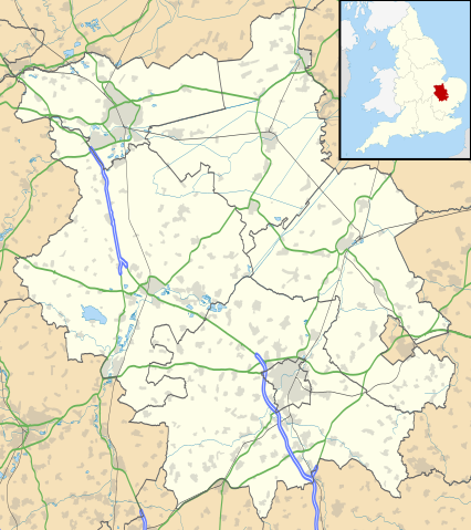
Map of Cambridgeshire, UK with the following information shown:
Equirectangular map projection on WGS 84 datum, with N/S stretched 160% Geographic limits:
|
| Date | |
| Source |
|
| Author | Nilfanion, created using Ordnance Survey data |
| Permission (Reusing this file) |
This file is licensed under the Creative Commons Attribution-Share Alike 3.0 Unported license. Attribution: Contains Ordnance Survey data © Crown copyright and database right
|
| Other versions | File:Cambridgeshire UK district map (blank).svg - Blank map |
File history
Click on a date/time to view the file as it appeared at that time.
| Date/Time | Thumbnail | Dimensions | User | Comment | |
|---|---|---|---|---|---|
| current | 18:41, 26 September 2010 | | 1,125 × 1,266 (1.79 MB) | Nilfanion | {{Information |Description=Map of Cambridgeshire, UK with the following information shown: *Administrative borders *Coastline, lakes and rivers *Roads and railways *Urban areas Equirectangular map projection on WGS 84 datum, with N/S |
File usage
More than 100 pages use this file. The following list shows the first 100 pages that use this file only. A full list is available.
- Abington Pigotts
- Addenbrooke's Hospital
- Anglesey Abbey
- Balsham
- Bar Hill
- Boxworth
- Brinkley, Cambridgeshire
- Burghley House
- Burwell, Cambridgeshire
- Caldecote, South Cambridgeshire
- Cambourne
- Cambridge Castle
- Carlton, Cambridgeshire
- Caxton, Cambridgeshire
- Chatteris
- Chesterton, Cambridge
- Cheveley
- Civil parishes in Cambridgeshire
- Comberton
- Coton, Cambridgeshire
- Cottenham
- Denny Abbey
- Duxford
- Eaton Ford
- Eaton Socon
- Ely Cathedral
- Eye, Cambridgeshire
- Eye Green
- Eynesbury, Cambridgeshire
- Flag Fen
- Fordham, Cambridgeshire
- Foxton, Cambridgeshire
- Fulbourn
- Gamlingay
- Girton, Cambridgeshire
- Girton College, Cambridge
- Godmanchester
- Grantchester
- Great Shelford
- Great Wilbraham
- Guilden Morden
- Hampton, Peterborough
- Hartford, Cambridgeshire
- Hemingford Grey
- Huntingdon
- Ickleton
- Imperial War Museum Duxford
- Isleham
- Kimbolton, Cambridgeshire
- Kimbolton Castle
- Landbeach
- Linton, Cambridgeshire
- Little Gransden
- Little Shelford
- Little Wilbraham
- Littleport
- Lode, Cambridgeshire
- Longthorpe
- Madingley
- March, Cambridgeshire
- Maxey, Cambridgeshire
- Melbourn
- Meldreth
- Mepal
- Milton, Cambridgeshire
- Northborough, Cambridgeshire
- Odsey
- Orton, Peterborough
- Perry, Cambridgeshire
- Peterborough
- Peterborough transmitting station
- RAF Brampton
- RAF Mepal
- RAF Wittering
- RAF Wyton
- Ramsey, Cambridgeshire
- Ramsey Abbey
- Reach, Cambridgeshire
- Sawston
- Sawtry
- Soham
- St Ives, Cambridgeshire
- St Neots
- Stanground
- Stilton
- Stretham Old Engine
- Sutton, Peterborough
- Sutton-in-the-Isle
- Swaffham Prior
- Swavesey
- The Abingtons, Cambridgeshire
- Thorpe Hall (Peterborough)
- Waterbeach
- Werrington, Peterborough
- Whittlesey
- Wicken, Cambridgeshire
- Wilburton
- Wimpole Estate
- Wisbech
- Witcham
View more links to this file.
Global file usage
The following other wikis use this file:
- Usage on ar.wikipedia.org
- Usage on bg.wikipedia.org
- Usage on ceb.wikipedia.org
- Usage on es.wikipedia.org
- Cambridge
- Grantchester
- Castillo de Kimbolton
- Peterborough
- Ely
- Huntingdon
- Saint Neots
- Plantilla:Mapa de localización de Cambridgeshire
- Wicken (Cambridgeshire)
- March (Cambridgeshire)
- Capilla del King's College
- Dullingham
- Down Field
- Dry Drayton
- Duxford
- Bar Hill
- Duxford Airfield
- Barrington (Cambridgeshire)
- Barton (Cambridgeshire)
- Alconbury Weston
- Alconbury
- Ashley (Cambridgeshire)
- Earith
- Ellington
- Elsworth
- Elton (Cambridgeshire)
- Haddenham (Cambridgeshire)
- Hauxton
- Harston
- Farcet
- Fen Ditton
- Benwick
- Bassingbourn
- Bluntisham
- Bottisham
- Bourn
- Brampton (Cambridgeshire)
- Buckden
- Fen Drayton
- Fenstanton
- Burwell
- Caldecote (South Cambridgeshire)
- Cambourne
- Hemingford Abbots
- Guilden Morden
- Great Wilbraham
View more global usage of this file.

.svg)