


Informatics Educational Institutions & Programs

Telecineguy (talk | contribs) m →Notable places: move |
Telecineguy (talk | contribs) |
||
| Line 21: | Line 21: | ||
*'''Alkali Flat Central Historic District''': 95-acre E and F Streets, between 9th and 12th Sts, (#84000929 on July 26, 1984) {{coord|38.584444|-121.489722|region:US-CA_source:gnis-218162_type:landmark|display=inline;title}}.<ref>{{NRISref |refnum=84000929|2009a}}</ref> |
*'''Alkali Flat Central Historic District''': 95-acre E and F Streets, between 9th and 12th Sts, (#84000929 on July 26, 1984) {{coord|38.584444|-121.489722|region:US-CA_source:gnis-218162_type:landmark|display=inline;title}}.<ref>{{NRISref |refnum=84000929|2009a}}</ref> |
||
*'''Alkali Flat North Historic District''': 23-acre D and 11th Streets (#84000933 on April 19, 1984). {{coord|38.58666|-121.487778|region:US-CA_source:gnis-218162_type:landmark|display=inline}}<ref>{{NRISref |refnum=84000933|2009a}}</ref> |
*'''Alkali Flat North Historic District''': 23-acre D and 11th Streets (#84000933 on April 19, 1984). {{coord|38.58666|-121.487778|region:US-CA_source:gnis-218162_type:landmark|display=inline}}<ref>{{NRISref |refnum=84000933|2009a}}</ref> |
||
*'''Alkali Flat West Historic District''': 67-acre E, F, and 8th Streets, |
*'''Alkali Flat West Historic District''': 67-acre E, F, and 8th Streets, almostly residential with some canals. (#84000933 on July 26, 1984) {{coord|38.585833|-121.493056|region:US-CA_source:gnis-218162_type:landmark|display=inline}}<ref>{{NRISref |refnum=84000933|2009a}}</ref> |
||
==Notable places== |
==Notable places== |
||
Revision as of 20:40, 14 September 2023
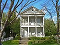
Alkali Flat Historic District | |
 A house in the West district | |
| Location | Sacramento, California |
|---|---|
| NRHP reference No. | 84000929 84000933 84000936 |
| Added to NRHP | Central and West districts: 26 July 1984 North district: 19 April 1984 |

Alkali Flat Historic District is a Historic district in Sacramento, California. Alkali Flat is the oldest surviving neighborhood in Sacramento. The older Alkali Flat buildings and homes were built between 1853 and 1869 by the upper class of Sacramento.[1][2][3]
History
As the older upper class houses, became less wanted Irish and Mexicans immigrants moved in the 1920’s. In 1920s the neighborhood got its name Alkali Flat, as white powder once coated the ground from seasonally in the Sutter slough with spring and winter flooded. All the home were old and run down by the 1950s, the city started a redevelopment program for Alkali Flat. The city zoned Alkali Flat as C-4 zone for business. KCRA Television moved in along with other businesses. The County of Sacramento built offices and parking in Alkali Flat. The Capitol Corridor project and I-5 work in 1991, removed house in Sacramento and some moved into Alkali Flat. [4] The art group Royal Chicano Air Force (RCAF) opened in 1960s in Alkali Flat.[5] It was one of the "most important collective artist groups"[6]A new city redevelopment program for Alkali Flat started on February 10, 1972. The “Redevelopment Plan Alkali Flat Project No 6” zoned some of Alkali Flat as residential, starting a effort to preserve the history of Alkali Flat. [7][8] Some historic homes were moved to Alkali Flat in the 1990s. [9][10][8]
The Blue Line (Sacramento RT) has a station, the Alkali Flat/La Valentina station and the Globe station that opened in 1987. [11][12]
National Register of Historic Places
In 1984 Alkali Flat recieved three National Register of Historic Places listings:
- Alkali Flat Central Historic District: 95-acre E and F Streets, between 9th and 12th Sts, (#84000929 on July 26, 1984) 38°35′04″N 121°29′23″W / 38.584444°N 121.489722°W.[13]
- Alkali Flat North Historic District: 23-acre D and 11th Streets (#84000933 on April 19, 1984). 38°35′12″N 121°29′16″W / 38.58666°N 121.487778°W[14]
- Alkali Flat West Historic District: 67-acre E, F, and 8th Streets, almostly residential with some canals. (#84000933 on July 26, 1984) 38°35′09″N 121°29′35″W / 38.585833°N 121.493056°W[15]
Notable places
Notable places in Alkali Flat Historic District:
There are 46 buildings on Central Alkali Flat National list:[16]Alkali Flat West has 17 buildings on the National list.[17] Alkali Flat North has 14 buildings on the National list.[18]
- J. Neely Johnson House Fourth Governor of California home. National Register #76000512 [19]
- Mesick House National Register #82002236.[20]
- Kuchler Row National Register #82002234.[21]
- Hubbard-Upson House, National Register #77000327 [22]
- Anton Wagner Duplex [23]
- Phoenix Milling Company now The Globe Mill [24]
- Van Voorhies House [25]
- Crystal Cream and Butter Company [26]
- Phoenix Flour Mill [27]
- California Almond Growers Exchange (1910-1915)
- Southern Pacific Hospital on 8th & F Street[28]
- Banta Mill (1898-1902)
- Burnett & Sons Novelty Wood Works
- Sacramento Hostel
- Gordon D. Schaber Sacramento County Courthouse
- Sacramento County Public Law Library
- KCRA-TV
- Zapata Park
- Neely Johnson Park
Gallery
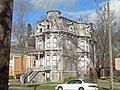
-
 Alkali Flat Central Historic District
 -
 Alkali Flat North Historic District
 -
-
 Anton Wagner Duplex
 -
-
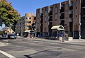 Alkali Flat/La Valentina station in 2018
 -
 Alkali Flat's Globe station


See also
- National Register of Historic Places listings in Sacramento County, California
- Old Sacramento State Historic Park
- Old Sacramento Chinatown
Further reading
- Alkali Flat North Historic District, National Register of Historic Places listing
- Alkali Flat West Historic District, National Register of Historic Places listing
- Sacramento's Alkali Flat, James Scott and Tom Tolley, 2010, ISBN 9780738571515
References
- ^ Alkali Flat History;alkalimansionflats.org
- ^ Flat/Mansion Flats Strategic Neighborhood Action Plan (SNAP) cityofsacramento.org
- ^ Back in Time, Alkali Flat, Sacramento, California, sacramentopress.com
- ^ niche.com
- ^ Orozco, Donna (March 3, 2021). "Arts Visalia celebrates influential Chicano artist Ricardo Favela, a Dinuba native". Visalia Times Delta.
Favela went on to found the Royal Chicano Air Force (FCAF) with Montoya and Estefan Villa along with others at Sac State.
{{cite web}}: CS1 maint: url-status (link) - ^ Nicolás Kanellos; Francisco A. Lomelí; Claudio Esteva Fabregat (1993). Handbook of Hispanic Cultures in the United States: Literature and art. Arte Publico Press. p. 195. ISBN 978-1-61192-163-2.
- ^ “Redevelopment Plan Alkali Flat Project No 6, cityofsacramento.org
- ^ a b "National Register Information System". National Register of Historic Places. National Park Service. April 15, 2008.
- ^ "Time Table for the Western Division #229 To Take Effect Tuesday, August 1, 1939 at 12:01 A. M." (PDF). Southern Pacific Railroad. August 1, 1939.
- ^ "Train links Sacramento, Bay Area". Lodi News-Sentinel. December 12, 1991 – via Google News.
- ^ "SacRT System Map" (PDF) (Map). Sacramento Regional Transit District. August 29, 2021. Retrieved July 16, 2022.
- ^ Walker, Bill (March 13, 1987). "Pride runneth over in city 'On the move'". The Sacramento Bee. pp. A1, A26.
- ^ "National Register Information System – (#84000929)". National Register of Historic Places. National Park Service. March 13, 2009.
- ^ "National Register Information System – (#84000933)". National Register of Historic Places. National Park Service. March 13, 2009.
- ^ "National Register Information System – (#84000933)". National Register of Historic Places. National Park Service. March 13, 2009.
- ^ Notable places in Central Alkali Flat Historic District noehill.com
- ^ Alkali Flat West Historic District , noehill.com
- ^ Alkali Flat North noehill.com
- ^ "NPGallery Asset Detail". npgallery.nps.gov. Retrieved November 28, 2021.
- ^ "National Register Information System – (#82002236)". National Register of Historic Places. National Park Service. March 13, 2009.
- ^ Kuchler Row, noehill.com
- ^ Hubbard-Upson House noehill.com
- ^ Anton Wagner Duplex parks.ca.gov
- ^ The Globe Mill, oftsatglobemills.com
- ^ Van Voorhies House, calisphere.org
- ^ Crystal Cream and Butter Company, crystalcreamery.com
- ^ Phoenix Flour Mill, calisphere.org
- ^ Southern Pacific Hospital calisphere.org


